Posts

Showing posts from February, 2011

Amazons 2011

Image
I told the team we should retire this year because we had already won the City Women's Championship in 2010, but they wanted to do it again. Our outfits this year are the most outrageous ever. We all got different colored shirts and decided we would match our hair and make-up to the shirt colors. And, we have inspired others: this year, the tournament saw new teams called the "Mini Me's", the "Tweeners" and the "Teenie Weenies" (maximum height 5'1"). We almost won again, but were edged out by 16 pins for first place.
Boca Chica, Texas

Image
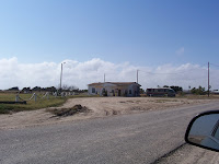
Boca Chica is a very small village about 15 miles straight east of Brownsville, about 2 miles from the Gulf, and a mile north of the Rio Grand. It was founded about 100 years ago by a hustler who advertised it heavily in Poland. He sold parcels to about 2000 investors. Thirty two houses were built. There are now 6 permanent residents. Water is trucked in from Brownsville. It's a very desolate area - the soil is so salty and sandy that virtually nothing grows. One photo shows the gas station/ bait shop at the entrance to the village. Folks surf fish in the gulf. Kay is standing by a group of floats that mark the entrance to the village. In the photo of Bil, the land over his shoulder is a wide salt flats, with low dunes about 2 miles behind him. Those dunes are at the Gulf. Apparently, depending on the storms and tides, sometimes the land along the shore becomes a barrier island, and the salt flats become full of sea water. We can only wonder what the weather ...

The South Padre Island Great Storm of Feb. 2011

Image
Don't laugh ! Snow on South Padre Island, even a trace of snow, doesn't happen once in 10 years. So this was a big deal. The little triangle of snow on our balcony was about 1" deep. We had a bad cold snap last Wednesday through Friday, the same days you in Michigan got a big dose of snow. We were actually at the bottom end of the same front that brought you the snow. The temp got down to about 27/28 two nights in a row. Thursday night it spit snow and freezing rain. The bridge that connects the island is 3 miles long and was a sheet of ice. The State put sand on the bridge, but they ultimately closed the bridge entirely about midnight. They re-opened it the next day at noon. The municipal systems down here seem sort of fragile, and our power went down both nights, and the water pressure reduced dramatically on Thursday night. Nearly all the maintenance people who work on the island live on the mainland, so they could not get to work and make things right. E...

Snowpocalypse 2011

Image
It was a late developing storm in Grand Ledge, but aren't they always, though? Predicted storms never seem to be as big, or arrive as timely as anticipated, either. I went outside to secure a garage window and bring a shovel inside Tuesday night around 11 P.M., there was probably 2 inches already, but it was tough to be certain with all the blowing. Winds were 31 mph, 4 below the blizzard threshold, and school was already cancelled. Woke to drifts, and blowing cold. Played and worked and came home with Sophia to Tiffani and Seamus having already dug fortifications, so I tried to film the snowball attacks with the phone. Pardon the change in orientation, I mistakenly figured the phone would follow along. School is cancelled again for Thursday. Abandoned vehicles litter northbound Lake Shore Drive, Chicago on Wednesday, February 2  morning. This is what the snowstorm blanketing much of the country looked like. The storm, which was covering ...

South Padre Island

Image
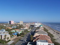
I thought I'd post some pictures from South Padre Island, so you can get a flavor of our environment. We are on the 1st floor of the building, just right of center. There are two floors below us, but they are the parking garage - the big blank wall shown here. Kay shown standing on our balcony. It's a 2 bdrm, 2 bath. The living room/kitchen area is quite small, but it's adequate for us. We see parasail surfers whenever the winds are up - which is almost always. The parasail shown is the view from our balcony. There are a couple of drilling platforms straight out from our building, perhaps 3 or 4 miles out. There are usually a couple of ships anchored out that far, waiting for a slot in the Brownsville harbor. The urban picture is taken from the top (11th) floor of our buiding, looking north. The farthest buildings are less than a mile away, and mark the end of the developed part of the island. The island goes on for perhaps 50 miles, but is a wilderness. You can ...